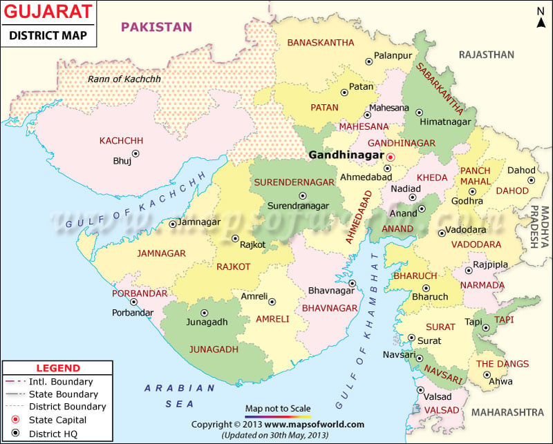
Description : The Map shows the capital of Gujarat, Gandhinagar, the district boundaries and the district headquarters. The international boundary with Pakistan is clearly demarcated on the map. The state boundary, which separates Gujarat from Maharashtra, Madhya Pradesh and Rajasthan, is also shown on the map. The Map also depicts the Arabian Sea.
| Code | District | Headquarters | Population (2011) | Area (sq km) |
|---|---|---|---|---|
| AH | Ahmedabad | Ahmedabad | 7,045,314 | 7,170 |
| AM | Amreli | Amreli | 1,513,614 | 6,760 |
| AN | Anand | Anand | 2,090,276 | 2,942 |
| AR | Aravalli | Modasa | 1,051,746 | 3,217 |
| BK | Banaskantha | Palanpur | 3,116,045 | 12,703 |
| BR | Bharuch | Bharuch | 1,550,822 | 6,524 |
| BV | Bhavnagar | Bhavnagar | 2,388,291 | 8,334 |
| Botad | Botad | 652,556 | 2,564 | |
| Chhota Udaipur | Chhota Udaipur | 1,022,185 | 3,237 | |
| DA | Dahod | Dahod | 2,126,558 | 3,642 |
| DG | Dang | Ahwa | 226,769 | 1,764 |
| Devbhoomi Dwarka | Khambhalia | 694,719 | 5,684 | |
| GA | Gandhinagar | Gandhinagar | 1,387,478 | 2,163 |
| JA | Jamnagar | Jamnagar | 1,464,411 | 8,441 |
| JU | Junagadh | Junagadh | 1,505,508 | 5,092 |
| KA | Kutch | Bhuj | 2,090,313 | 45,652 |
| KH | Kheda | Nadiad | 2,048,861 | 3,667 |
| MH | Mahisagar | Lunavada | 1,007,582 | 2,500 |
| MA | Mehsana | Mehsana | 2,027,727 | 4,386 |
| Morbi | Morbi | 1,007,954 | 4,871 | |
| NR | Narmada | Rajpipla | 590,379 | 2,749 |
| NV | Navsari | Navsari | 1,330,711 | 2,211 |
| PM | Panchmahal | Godhra | 1,630,758 | 3,272 |
| PA | Patan | Patan | 1,342,746 | 5,738 |
| PO | Porbandar | Porbandar | 586,062 | 2,294 |
| RA | Rajkot | Rajkot | 2,961,338 | 7,550 |
| SK | Sabarkantha | Himmatnagar | 1,375,600 | 4,173 |
| Gir Somnath | Veraval | 1,236,783 | 3,754 | |
| ST | Surat | Surat | 6,079,231 | 4,418 |
| SN | Surendranagar | Surendranagar | 1,586,351 | 9,271 |
| TA | Tapi | Vyara | 806,489 | 3,249 |
| VD | Vadodara | Vadodara | 3,135,383 | 4,312 |
| VL | Valsad | Valsad | 1,703,068 | 3,034 |
Gujarat Railway Map shows the district’s rail network Gujrat, significant stations, railway zones, and trains connecting the main towns and cities across the state.
Gujarat Road Map highlights the national highways and road network of Gujarat state in India. Road map of Gujarat showing the major roads, district headquarters, state boundaries, etc.